


Change amid the Changeless
As I push open the cumbersome steel door and step out of the tunnel, the brisk morning air touches my skin. I descend to the riverbank amid the roar of the Kurobe Dam releasing water. The spray blows on me as a fine mist. Crossing over a small bridge to the other side of the river, I find a gentle path leading downstream along the river.
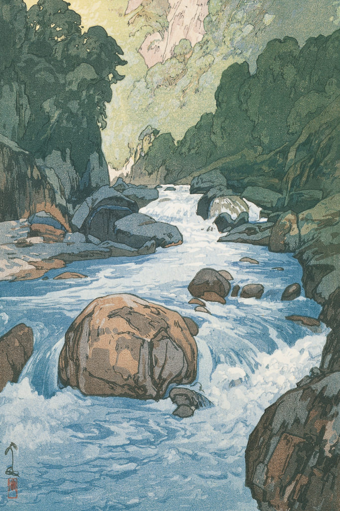
A drop of water that started just below the top of Mt. Wahaya joins several streams, eventually becoming a torrent that flows down into a deep valley surrounded by cliffs. The Kurobe Gorge was carved by avalanches and the flow of the Kurobe River. Known as the upper and lower corridors upstream and downstream respectively. The lower corridor constitutes a long stretch of small paths less than one meter wide, carved out of the precipitous cliffs. This is the “Old Japan Electric Trail” that was once cleared for power development. The road, which remains closed due to heavy snowfall for most of the year, is open only for a short window-from autumnwhen the snow has melted the most until the next snowfall-drawing in hordes of eager alpinists.
The Kurobe Gorge is a hidden secret spot that evaded human contact for a long time due to its cragginess. It is thought that in the Edo period, the Kaga clan forbade entry into the valley, and only officials called Kurobe Okuyama Mawari were allowed in. The area was opened to the public in the Meiji era, and many climbers gravitated to Kurobe. In 1917, the first survey team set foot in the gorge, slated as a suitable place for the construction of a hydroelectric power plant due to the volume of water and the gradient of the river. In 1920, a horizontal trail was carved out of the 13 km-long cliffs from Zelkova-daira to Sen-nin Valley for the purpose of transporting construction materials for the power plant. Then in 1929, the Nippon Electric Power Company (now Kansai Electric Power Co., Inc.) built a 16.6 km-long work road upstream from Sen-nin Valley. Although these works were highly unfeasible and many workers lost their lives, the development of Kurobe continued as a national policy. The Taisho era (1912-1926), when Hiroshi Yoshida was actively involved in the North Alps, was also the dawn of such development.
illustration | Yohei Naruse
illustration | Yohei Naruse
Under a cloudless blue sky, a vast rock wall with an elevation difference of over 500 meters stands before me, basking in the white morning rays. As it is so deep and steep, the top of the mountain is obscured from view from the valley floor. As if wandering through a maze, the former power company trail leads to the core of the lower corridor, which is flanked by cliffs. Gradually, I begin to lose track of where I was even walking. The valley is spanned by snow bridges which could collapse at any moment, and lingering snowdrifts roll down into the valley. Jade-colored water, slightly muddy and white, flows far below the sheer cliff. I gingerly step forward, ensuring my rucksack does not snag on the rocky corner.
The temperature rises as the light reaches the deep valley, bringing with it the smell of fresh grass. As I walk down the slope with a cold, dry wind blowing, we arrived at the crossroads of the gorge, where the streams from east to west empty into the Kurobe River at the same place. The breathtakingly cool and clear water has a bluish-green hue in the afternoon sunlight. A small rainbow adorns the waterfalls flowing down from the Tsurugi marsh.
The bottom of the path attached to the precipice was cut off by a few dozen meters.
illustration | Yohei Naruse
illustration | Yohei Naruse
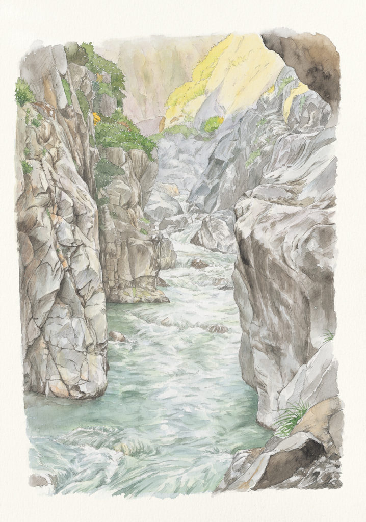
illustration | Yohei Naruse
In his book “On the Beauty of Takayama,” published in 1931, Hiroshi Yoshida left the following description:
The edge the Kurobe River is flanked with precipitous cliffs, of which the two most spectacular and steep cliffs are known as the upper and lower corridors. However, the lower corridor was destroyed when the power station was built, so I never felt like going back there again; it was most regrettable to see the manner in which it had been ruined. Fortunately, the upper corridor is still untouched, and although it is a little smaller than the lower corridor, its mysteriousness is no less beautiful than that of the lower corridor. The Kurobe River is literally a deep ravine, and the water flowing at the bottom of the towering cliffs is clear and bright beyond compare. Moreover, the water in the upper reaches of the river is never muddy, even when it rains, which could even be likened to a mystery in its own right.
Convinced that the true beauty of nature lay in high mountains and deep valleys, Hiroshi Yoshida ventured into the mountains and published his works “Kurobe River” in 1924 and “Kurobe River Corridor” in 1936. After the development of the area, he no longer felt like going to the lower corridor, but in 1928 he wrote: “Even though the power plant has destroyed it somewhat, it definitely remains a mysterious place.
In 1956, the construction of the Kurobe Dam (Kuroshi Dam), which required more than 10 million workers and resulted in 171 fatalities, finally began. Although this was six years after the artist had passed away at the age of 73, I wonder if it ever crossed his mind that the valley he so cherished would be transformed to make up for the shortage of electricity during the period of rapid economic growth, or that it would become a major tourist destination.
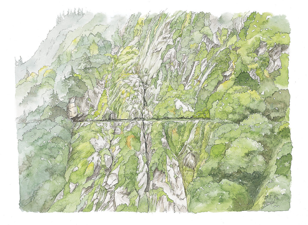
illustration | Yohei Naruse
I pitch my tent at Asohara Onsen Hut, which is thronging with climbers who had come for the opening of the lower corridor, and set off before dawn the next day. I stroll over to Keyakidaira along a horizontal footpath built along a contour line at an elevation of 1,000 meters. The gouged surface of the rock, surely imbued with the history and sorrows of many people, is now covered with thick moss, as if blending in with nature 90 years on.
As noon approaches, dim clouds begin to spread, portending the arrival of rain. Looking back, I can just about make out the ridgeline of the Ushiro Tateyama Peaks across the deep valley, almost unchanged from the time when Hiroshi Yoshida walked it.
<PAPERSKY no.30(2009)>
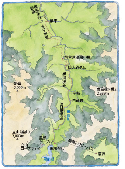
route information
The lower corridor route is one of the few routes in Japan that offers a truly spectacular view of a deep valley. It is usually around late September or early October that the roads collapsed due to avalanches are repaired, and the routes are opened. However, there are some years when the road does not open due to the sheer amount of snowfall, so it is best to contact the Toyama Prefectural Police Mountain Rescue Squad. While most hikers will have no trouble walking along the provided route, there are no mountain huts between Kurobe Dam and Asobara Onsen Hut, so you need to have the stamina to walk the 20km or so route in one day, always being careful of falls and falling rocks. Once you enter the mountain, there is no escape route, so do not attempt it lightly. The course takes around 7.5 hours, while the course in reverse takes even more time. There is a snowy valley, so best to bring light crampons. The Kurobe Dam can be entered from Ougisawa on he Nagano Prefecture side.
Yohei Naruse
Born in Gifu Prefecture in 1982. Graduated Tsuru University, Graduate School. Following a stint in advertising, he currently works as a freelance writer and illustrator.